By Emily Zawacki, GSA Science Communication Intern, Ph.D. Candidate Arizona State University
In a part of the world that receives less than 100 mm of rainfall per year, the areas west of the Nile River in Egypt have long been viewed as a “lifeline” through the hyperarid Sahara Desert. Much of previous research in the region has focused on how the Nile Valley served as an important corridor for some of the earliest members of our species—Homo sapiens—to disperse “out of Africa” beginning around 100,000 years ago and for subsequent human habitation.
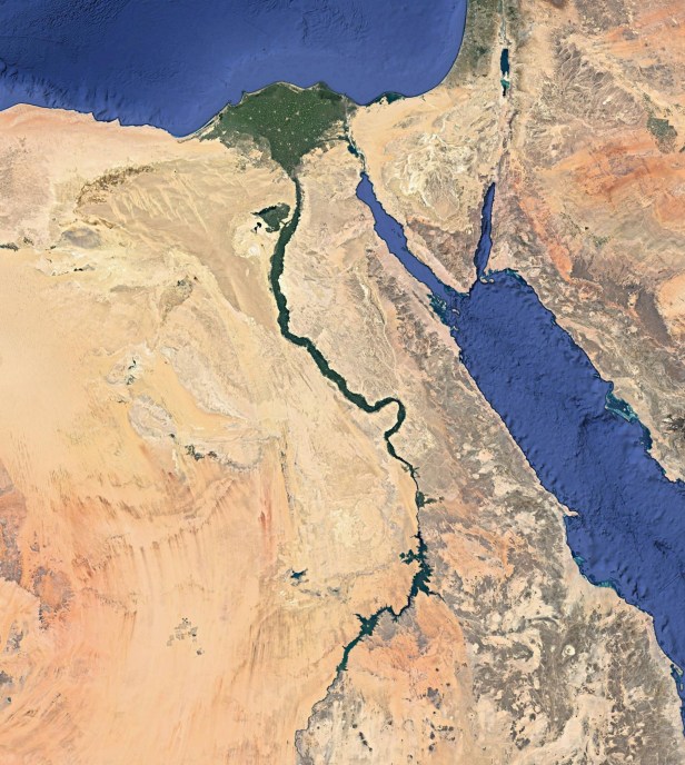
However, continued research has shown that parts of the modern Sahara Desert were wetter in the past, suggesting that pathways and environments of early humans in these now harsh desert regions were more complex than previously thought.
Dr. Kathleen Nicoll, an Associate Professor at the University of Utah, is a geoarchaeologist who studies how people have responded to climate change throughout prehistory in areas of the eastern Sahara, including southern Egypt and northern Sudan. She is the winner of the 2019 Geological Society of America Geoarchaeology Division’s Rip Rapp Award and runs the popular geoscience Facebook page “Geomorphology Rules.”
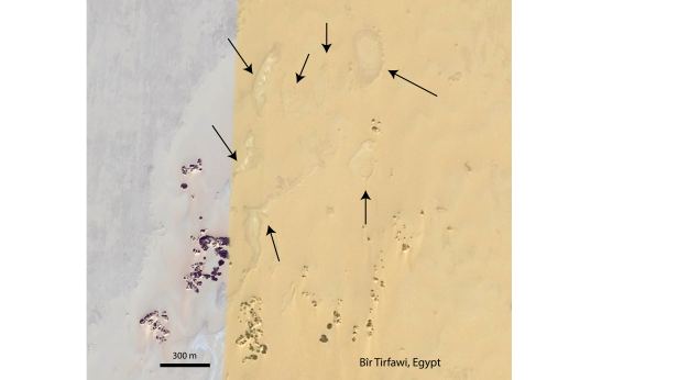
During an undergraduate research project at the National Air and Space Museum of the Smithsonian Institution, Dr. Nicoll used Landsat images—satellite imagery of the Earth—from the central and eastern Sahara to identify hundreds of deposits formed by ancient springs and lakes. The deposits visible in the satellite imagery indicate the former presence of standing water in this now hyperarid environment. While earning her Ph.D. at the University of Arizona, Dr. Nicoll tested the observations made from the satellite imagery and went to study the deposits in the field. She continues this work today.
Not only does the discovery of deposits from ancient lakes and springs indicate that parts of the Sahara used to be wetter in the past, but researchers also find archaeological artifacts associated with these deposits from ancient people who occupied these now-defunct water systems.
“So the intriguing question really is, why were people there? When were they there? When did they leave? And is there any pattern to that?” said Dr. Nicoll.
To answer such questions, Dr. Nicoll and colleagues study and map the deposits and associated archaeology in the field. They collect sediment samples to date how old the deposits and the associated artifacts are, working to reconstruct a record of when in the past the environment was wetter and patterns in human habitation and cultural activity.
However, conducting field work in these parts of the eastern Sahara can often be quite challenging. In the desert, records are ephemeral and preservation potential is often poor, so finding suitable material to date and analyze can be difficult. But beyond the geology itself, field work in the region requires careful geopolitical navigation.
“Right now, some of the issues are not whether the data are there, it’s do you have the access and the financial means to go in and collect them,” said Dr. Nicoll.
Dr. Nicoll hypothesizes that over time, as smaller watering holes formed and dried up, people migrated to the Nile corridor, which was a reliable source of water. However, that migration resulted in the Nile becoming over-utilized and led to the creation of hierarchical organizations of people who were in charge of water rights.
“In my mind, understanding the desert is important for understanding how people became civilized and how people decided to set up ruling structures about resource management and allocation for resources,” said Dr. Nicoll.
Reconstructing these past environments and understanding how early humans responded to climate changes in the eastern Sahara is important because it serves as a foil for modern conditions.
“I always think it’s important to understand the basic parameters of how people live, because I think that we as a culture take for granted that our systems are going to be in place and not disrupted by climate change. Today, we know climate disruption is real, that our climate is changing, and that our desert areas are expanding in some places. Populations are expanding, and there’s less water available,” said Dr. Nicoll.
By studying our not-too-distant past, researchers like Dr. Nicoll are able to better understand how people culturally adapt or shift their environments to cope with arid climate change. A difficulty, though, is due to the vastness of the Sahara Desert, which encompasses an area approximately equivalent to that of the United States. The African continent is comparatively understudied, and more research is required to address the diversity of sites across the Sahara.
“There’s always more to do because there’s always more questions you have, and almost any scholar would probably agree that you start out with a simple thing and it becomes more complicated, and then you have more questions sometimes at the end than you started with,” said Dr. Nicoll. “I think for me, the ability to go and satisfy my curiosity on the ground will always be there.”
Beyond her research, Dr. Nicoll works to provide a platform for geoscience communication and interaction with the public. Dr. Nicoll started the “Geomorphology Rules” Facebook page for her geomorphology class at the University of Utah as a way to communicate with students and share relevant YouTube clips and articles. However, she quickly found that her reach was extending beyond the classroom, and the page began to attract a global audience. The page now has over 135,000 followers and receives over one million interactions every month.
“I post a lot now about the nexus of politics and policy with science, in that many of the science-informed policies in America are now being rolled back by the current administration,” said Nicoll.
On the page, you can find a variety of posts such as ones about the Endangered Species Act, the Department of the Interior, changes within the National Parks system, as well as landscape photos from class field trips and posts on Earth’s fascinating surface processes.
With the page, Dr. Nicoll seeks to create an accessible dialog for the community.
“I think there’s an underappreciated existing market for science-based content, as well as intellectual, philosophical kinds of discussions about discovery, the wonderment of the world, and emerging things that are going on in academia,” said Dr. Nicoll.
Dr. Nicoll presented her recent work titled “Emerging environmental and geoarchaeological records from the NE Sahara and their relevance in dispersals ‘Out of Africa’ during the Quaternary” at the 2019 Geological Society of America Annual Meeting in Phoenix, AZ. You can connect with the “Geomorphology Rules” page on Facebook at https://www.facebook.com/GeomorphologyRules/
###
The GSA Science Communication Internship was a program offered at the GSA Annual Meeting in Phoenix, AZ, designed for student attendees interested in science communication as a possible alternative career path. Interns were paired with GSA’s Science Communication Fellow in order to gain experience in making science clear and exciting, under the tutelage of a professional writer. Students were assigned to conduct interviews with presenters at the meeting and to compile summaries capturing the significance of the presenters’ work for a non-technical audience. Media assignments and mentoring were useful learning experiences and exposure opportunities for students seeking to expand their knowledge into geoscientific reporting.

Thanks for the article, Ms. Zawacki and Speaking of Geoscience! Wish more scientists would take the time to communicate about their work and about science issues like Dr. Nicoll does. From a faithful fan of “Geomorphology Rules.”