by Dean Moosavi, Education Programs Coordinator at the Geological Society of America
For the third installment of this GeoTeachers blog series, I thought I would take a step back from discussion of our summer workshops to look at the wider issue. Developing a workshop focused on the field is a lot of work. It poses unique challenges of cost, timing and accessibility that could be avoided by conducting a workshop at a conference or an on-line webinar. Most K-12 students of Earth Science attend schools that don’t have the ability to run field trips today. With the challenges involved, why bring teachers to the field at all?
Experiencing a geoscience phenomenon or challenge in a classroom or on a screen is as different from the perspective one gets from scrambling over a rock outcrop or cruising down a century old mine drift as the difference between watching a PBS documentary on TV compared to a live performance of Shakespeare in the Park. One affords easy access and ability to draw upon diverse sets of data with the click of a mouse. The other can be physically challenged but affords an inherently integrated sense of the structures and processes involved in a place. The first is two-dimensional; the latter, three-dimensional. The one is essentially a model of reality. The other is reality.
Even the best teacher is going to be challenged to describe a phenomenon or feature that they have only read about in books or seen on TV. That same teacher, however, can provide a deeper understanding of the same subject when they have walked past eroding sediment revealing a paleo-landscape, measured the strike and dip of sandstones along the Front Range, or ascended a trail from Precambrian granite past a profile of Paleozoic and Mesozoic sedimentary strata across the Great Unconformity. The risk posed by flash flooding in a narrow canyon is far more meaningful when one is standing next to a quiet stream and is faced with the prospect of how to climb to safety when seeing how high damage from floods a few years prior extended.
GSA members put the principles of field learning into practice in December last year, when we were privileged to have the opportunity to work with teachers and faculty at the American Geophysical Union (AGU) Fall Meeting in New Orleans, Louisiana. AGU’s Manager for Higher Education Pranoti Asher invited GSA to share a field trip with attendees of their GIFT (Geophysical Information For Teachers) Workshop. GSA Member Dinah Maygarden of the University of New Orleans and I partnered to help our attendees understand the geophysical basis for the founding of New Orleans in this location and how the reasons for the city’s founding also laid the basis for its vulnerability to flooding in the past, present, and future. We wanted our attendees to understand how very small changes in elevation resulting from deltaic process proved so critical in determining the impact of the Hurricane Katrina tragedy. We also sought to demonstrate that effective study of geology is possible and relevant for residents of urban areas even if teachers must work a bit harder to peer beneath the infrastructure of modern cities.
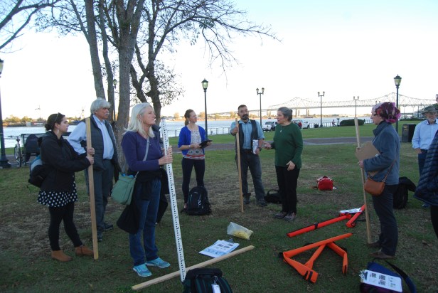
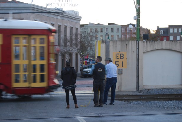
Before setting out along the New Orleans Riverwalk we shared basic diagrams of delta geomorphology portraying elevated levees formed via semi-annual flooding along river distributaries separating backwater swamps. We showed historic maps indicating how the particular arrangement of the current Mississippi River and older distributaries Bayou St. John and Bayou Sauvage created a perfect location for a portage for the transport of goods from the river to the north and east while also providing relatively high ground for the establishment of a settlement. Walking along the river past the ruined skyscraper that once housed the New Orleans International Trade Center served as a reminder of the scale of the disaster a dozen years ago. About 15 minutes on foot brought us to an open area on the artificial levee allowing us to spread out with the surveying equipment we had carried with us. Behind us to the east, the mighty Mississippi was relatively low, with mud flats showing in places below the rip rap that protects the artificial levee from erosion. To the west, the artificial levee sloped down to the gentler, yet ever downward, slope of the natural levee toward the densely packed buildings of the French Quarter. A concrete sea wall with a large gate separated us (and potential flood waters from the river) from the French Quarter.
Our information packets contained Google Earth images and LIDAR-based elevation maps of this area, indicating how this HIGHEST area of New Orleans slopes downward away from the river…so far that a mere 10 blocks through the French Quarter would bring a pedestrian to the former edge of the backwater swamps, land at three feet above sea level, where the post-Katrina flooding stabilized. All neighborhoods beyond this line, housing hundreds of thousands of people, were flooded during Katrina. One did not need the maps and images to see the problem, merely looking at the slopes and river left participants asking whether the French Quarter was even above the current elevation of the river.
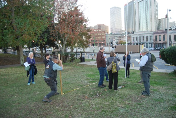
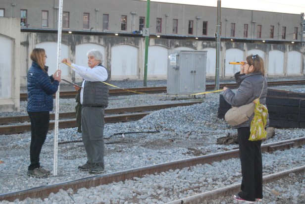
Fortunately, we brought tools to quantify the relationship between the river and landscape. No, we did not bring expensive high-end Total Stations, we brought sight levels, tape measures and stadia rods to do some simple surveying of the slope from the top of the artificial levee down to the flood wall and streets of the French Quarter to the west and the river to the east. We choose these tools as they are simple enough that a teacher with limited resources could use meter sticks, string and a level from the shop to build functional equivalents for use with our technique with students in a school yard.
The sight of nearly twenty teachers learning to use survey tools to measure parallel lines down the levee toward the city no doubt caused passers-by to wonder what was going on, and the activity did challenge the teachers at first and when faced with a streetcar that had no interest in waiting for their work to be concluded. Nonetheless, the exercise offered a clear mechanism for affirming that the top of the flood wall was below the levee and how much the city itself would be below river level in any sort of flood. The teachers experienced a hands-on activity that they could conduct with their own students at their school that could be used to provide quantitative data for analysis and comparison with professional data sets. Moreover, working in the field demonstrated to the teachers another key aspect of science that is often lost on students in computer-driven classrooms, the very real problems that arise in collecting data, sources of error and the need to improvise when facing such challenges. In this case, our measurements became increasingly difficult as the late afternoon light made the scopes increasingly difficult to see through. Further, we could not access the river because the concrete steps we had planned to use were blocked off behind a new construction project. Our improvised solution of lowering a stadia rod to the river from a quay could not be achieved safely.
This real-life experience making quantifiable geomorphic measurements relevant to solving a geoscientific problem using tools available to the average teacher is an experience that can only happen in the field. The next blog in this series will discuss the power the field approach can have when a knowledgeable expert leads our group in the field in the manner that GeoTeachers brings to its participants.
Dean Moosavi is the Education Programs Coordinator at the Geological Society of America based in Boulder, Colorado, smoosavi@geosociety.org. He has served as a lake surveyor, K-12 teacher and geoscience educator at all levels of academia. His teaching and research focus include place-based education, pre and in-service K-12 teacher training, coastal geomorphology and boreal/arctic biogeochemistry. Dean served as a volunteer with the Minnesota Mineral Education Workshop for 17 years before coming to GSA.
