By Rania Eldam Pommer, PhD Candidate- Colorado School of Mines
The following post is based on a research project funded by a 2017 GSA Graduate Student Research Grant. Rania’s research proposal was titled “Lithologic controls on critical zone processes in a variably metamorphosed shale-hosted watershed,” and she presented her results at the 2017 AGU Fall Meeting in New Orleans and the 2017 Goldschmidt Conference in Paris. GSA is currently accepting applications for 2019 Graduate Student Research Grants; the application deadline is 1 February 2019.
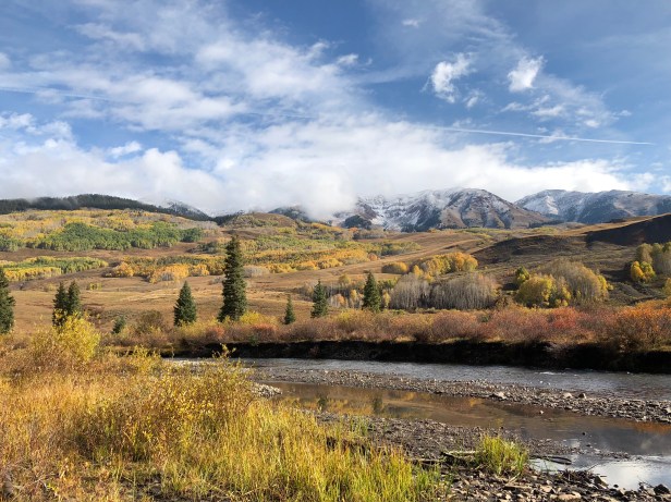
Driving along the roads of Crested Butte, Colorado, one begins to notice the unique feel of the small resort town – the fresh mountain air, the unparalleled landscapes, and the lodges and buildings nestled along the windy turns and hillsides. This land was first inhabited by the Ute indigenous people, who used this area as a summer respite until they were displaced by European-Americans in the 19thcentury. Coal and silver mines cropped up in Crested Butte’s widely heterogeneous landscape during this period of displacement, highlighting the town’s national geologic significance, as these mineral commodities were sought after across the country. The population of the town swelled and shrunk according to national mineral economics until the mid 20thcentury, when a ski area was built and became the central attraction of the town. This area, known as the East River Valley, is a significant watershed, supplying both this area and localities downstream with drinking, recreational, and agricultural water resources. Crested Butte’s hillsides and valleys provide land for community development amongst local residents, expansive ranching practices, and a large component of year-round tourism. This landscape is the framework for my research on how spatial changes in rock properties can affect both the natural and man-made environments.
Shale is the predominant bedrock for the valley, which affects the communities of Crested Butte, and the river quality itself. This bedrock is a sedimentary rock that was formed in low-energy, deep-water environments, and contains a particularly high concentration of a certain group of minerals – clays. Each clay mineral has a unique atomic structure, and due to these seemingly very small differences, large-scale physical and chemical effects can be triggered. Take, for example, the concept of swelling clays. In a specific type of clay, the inter-particle spacing between layers of atoms can provide a perfect environment for water molecules to inhabit. When water molecules inhabit this space, the layers of minerals get slightly pushed apart due to molecular forces. On a molecular scale, that shift may be small, just a few angstroms (a measure used to describe the size of a hydrogen atom), but on a large, human-concerning scale, clays saturated with water can swell centimeters to meters, and then shrink once the water is removed. Imagine what happens when a house is built on ground with a large percentage of minerals that exhibit this behavior: the very rigid foundation would be forced in multiple directions for extended periods of time, eventually leading to strength failure and cracking of the foundation.

Another repercussion of bedrock shales with high clay volume is that they break apart and weather fairly easily compared to other, more competent, rock types. Essentially, this means that the atomic bonds holding clay particles together can break and split apart when faced with minimal forces. This effect, in addition to the swelling properties of certain clays, can wreck havoc on homes in the area. A beautiful home located on a hillside of the East River Valley, overlooking mountains and river plains, may have a cracking foundation and be underlain by rock that is steadily wearing away. At some critical point, both the foundation and underlying units might fail completely – leaving parts of that picturesque home tumbling down the hillslope.
On a tangential note, when the shale weathers and material is removed, that material generally deposits into the local water body. In the case of Crested Butte, that local water body is the East River. Inputs from the weathered shale can be both beneficial and harmful to the water, as well as to Earth’s flora and fauna that utilize that water (including much of the Western slope of Colorado). When materials which were previously stored in the stable rock formation are released into a more biologically accessible form, this can provide good nutrients to the environment (such as carbon, nitrogen, and potassium), but also harmful elements (such as arsenic or heavy metals). Even too much of the “good” nutrients can be detrimental to an ecosystem. Thus, characterizing the rock properties of bedrock in a system that is undergoing modern-day earth surface processes is critical to predicting the evolution of geologic hazards and water quality.

Although shale is the primary bedrock type across the East River Valley, in certain parts of the valley the rock formation has been altered by high temperatures, causing changes in the molecular structure and subsequently, its weathering properties. My research aims to understand and predict how these temperature effects will change the land surface across the valley, and what implication those changes will have on land development and water resources. During my work, I have found that in areas of high thermal effects, rock competency (resistance to weathering) increases. This change can be attributed to several processes. First, clays, when introduced to very high temperatures (>300°C), begin to rearrange at the molecular level. These changes slowly convert swelling clays into other, non-swelling forms of clay minerals. By removing the swelling process, constant hydration/dehydration of the rock no longer breaks apart surrounding rigid structures. Another process that controls the shale’s resistance to weathering is the movement of fluids brought up during mountain-building events. These fluids are saturated in mineral building blocks, such as calcium and carbon dioxide, which fill the tiny pores spaces in shales, both underground and at the surface. As these saturated fluids mix with surface water, which is unsaturated in these chemicals, minerals like calcite begin to precipitate out of the solution and cause micro-scale cementation in the shale. Cementation processes block tiny fluid pathways, and decrease a fluid’s ability to continue moving through that rock. By preventing fluids from moving through tiny pore spaces, less physical breakage of the rock occurs, and fewer particles can be transported from the rock into the water.
When we can see these changes in the rock across the East River Valley, we can begin to understand why some outcrops of the underlying shale pose risks to land development and water quality, while others may not. By taking these rocks and outlining their properties (e.g. mineral makeup, inter-particle spacing, particle sizes, and inter-mineral relationships), my research hopes to better predict where the underlying geology in the idyllic East River Valley can pose a risk to the land which we build our homes on and the water which we drink. As humans look to an ever-growing population and need for increasingly efficient land use, understanding the land which provides the template for our communities to live upon will become more critical to our sustained futures.
###
