by Larry O’Hanlon, Independent Science Writer and Editor
Videos of erupting fissures, collapsing calderas, and glowing rivers of lava are grabbing all the clicks and headlines, but the scientists working overtime on the Kīlauea eruption and summit caldera subsidence are seeing something more: a revelation or two about how volcanoes like Kīlauea work and how to study them.
Although the latest eruption of Kīlauea began 35 years ago, the headline-grabbing events in the lower Puna area began on 30 April with the collapse of the long-lived Pu’u O’o vent and was followed by a 6.9-magnitude earthquake, the evacuation of more than 2,700 residents, and the destruction of hundreds of houses by fissure eruptions and lava flows in several subdivisions. There have also been explosive ash–producing eruptions at the summit of Kīlauea and dramatic slumping and subsidence of the caldera.
Throughout all this, the scientists of the U.S. Geological Survey’s (USGS) Hawaiian Volcano Observatory (HVO) and colleagues from the University of Hawaii and other institutions have provided critical information that has saved lives. They have done such an impressive job that one might think, watching the events unfold from the mainland, that these scientists have it all figured out, that they have a thorough understanding of Kīlauea. The truth is, this eruption is surprising scientists and challenging some of their basic ideas about the workings of volcanoes like Kīlauea.
Safety First
“First of all, our main focus is to provide information to emergency managers,” confirmed Tina Neal, scientist-in-charge at HVO. Their top priority is always to protect lives, despite all the amazing research possibilities provided by the eruption. “We can’t get lost in research. Homes are being destroyed. It still is a crisis and a hazard zone.”
Luckily, some research goes hand-in-hand with public safety. So Kīlauea’s surprises and its deluge of data has scientists doing a lot of science on the fly, figuratively and literally (more on that below).
“This might be the largest scientific response to an eruption in the United States since Mount St. Helens,” said Neal. “It’s very complex with an eruption of lava in the lower East Rift Zone and ongoing collapse at the summit 40 kilometers away. Early on we had more than 50 people working here on the response. Everybody has had to be very nimble.”
Most of those people are still working on the eruption even if they aren’t on location, like Weston Thelen, a seismologist at the USGS Cascades Volcano Observatory in Vancouver, Washington.
“It’s been full speed ahead on Kīlauea,” Thelen said. “The eruption is really interesting because it’s erupting in two different places: the summit (Halema’uma’u) and the east rift (lower Puna, Leilani Estates). It allows us to test ideas about the magma plumbing system. We’d learned little bits and pieces and windows into what’s happening in the past. This is an unprecedented opportunity to test hypotheses.”
Surprise
One plumbing-related surprise was in late April when the lava-filled Pu’u’ O’o Crater abruptly drained out.
“The magma within Pu’u O’o—all of a sudden it was gone,” recalled Thelen, who started at once trying to figure out where all that molten rock went. “We started looking at the seismometers down the rift.”
They discovered that as the magma moved past seismic stations the tremors increased, then subsided as the magma passed.
“Then we could see it had stalled under Leilani Estates. So we could issue a warning of a possible rift eruption,” Thelen said. “You’re not really able to make those types of statements without this long history of observation.”
That data and history comes from a well-established network of geophysical equipment—some collecting data for decades—on the ground monitoring the vibrations of the passing magma as well as the bulging and subsiding of the ground. Among the things that the instruments monitor is location in three dimensions (with GPS), seismic signals, and the tilt of the ground.
Back at the summit, other researchers were worried about something else: explosions.
“We knew things were starting to happen when magma drained from Pu’u O’o,” said Kyle Anderson, a research geophysicist at the USGS in Menlo Park, California. It’s well known that draining magma from the rift zones can lead to depressurization of the summit and disappearance of Kīlauea’s summit lava lake. According to the accepted theory, explosions could then start at the summit as groundwater seeped back toward the hot, drained crater. The water would flash into steam and blast its way out. “That was our first matter of concern,” which led to the closing of the Volcano National Park, he said.
But that’s not exactly what the volcano did.
Surprise, surprise
As predicted, the explosions occurred but, surprise, surprise, for entirely different reasons, explained Don Swanson, an HVO research geologist. Instead of being caused by steam, the explosions were likely powered by gases coming out of the magma.

“This is very different from our thoughts,” said Swanson, who spoke by phone from the dining room of the Volcano House overlooking the Halema’uma’u caldera. From there he could look out to the southwest and see the expanding caldera reaching out toward the evacuated HVO headquarters, across the caldera. “In 1924, explosions threw out blocks of rock probably by the same mechanism.” That historic case was attributed to steam explosions.
“This will cause us to rethink that eruption,” said Swanson. “It’s really an eye-opener situation for us.”
“It’s a fundamental difference in our thinking,” Anderson concurred.
Explosions and ash emissions at the summit largely ended in June, but large-scale slumping of rock around Halema’uma’u continues, greatly increasing the volume of the crater. These slumping events have settled into a sort of rhythm, occurring roughly once per day in association with an earthquake with equivalent magnitude exceeding 5.0 roughly once per day.
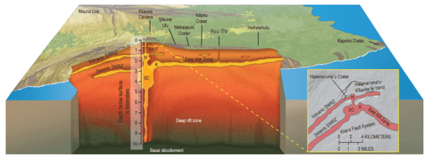
Mismatched Lava
Another scientific puzzle has been tracking the magma from the summit to the eruption in lower Puna geochemically. It’s not enough to have seismic signs of the magma moving to Puna. To understand the volcanic plumbing, scientists also need evidence that it is truly the same magma that was up at the summit.
To do this, lava is being collected manually, sometimes several times per day, taken back to a lab at the University of Hawaii in Hilo, and analyzed in just hours.
“We haven’t yet seen summit magma erupting in lower Puna. So magma draining from the summit must be stored somewhere along the way,” Swanson said. “We suspect what erupted first in Leilani Estates was magma that had been stored in the rift zone and pushed ahead of the magma that drained from the summit.”
“There’s still debate about how much summit magma is going right down to the eruption site (in lower Puna), versus being stored in the rift,” said Anderson. “The link between the summit and the rift eruption is becoming more clear, but many questions remain.”
Based on historical eruptions in the lower East Rift Zone, said Anderson, it is possible that the current fissure eruptions in Puna will stop in several months. However, the current scenario could play out differently, in part because the mechanism by which the eruption ultimately ends is not well understood. About the only thing that is certain is that scientists will be sorting out the details for a while.
“The data that’s coming out of this is going to fuel research for years to come,” said Anderson.
Science on the Fly”
The other revolution that has been taking place behind the scenes of the Kīlauea eruption is in the sky. For the first time in a major U.S. eruption, drones have been put to work zipping in and out of gas plumes, mapping out changes to the ground and checking for lava outbreaks that have endangered lives.
“We’re contributing to lots of science,” said Angie Diefenbach, who leads the Unmanned Aircraft Systems (UAS) team for HVO. Hexacopters and fixed-wing drones are providing digital elevation models (DEMs), tracking lava flows, and measuring deformation of the land caused by the magma moving underground. The aircrafts also carry gas sensors to measure sulfur dioxide (SO2), carbon dioxide (CO2), hydrogen sulfide (H2S) and gaseous water (H2O).
“We have been doing flights under plumes and over fissures,” explained Diefenbach. “We can sample different plumes and get gas emission rates. The same work if done by hand would take hiking and driving and could take all day. With the UAS it takes 15 minutes. We’ve been doing almost everything with them.”
The drone cameras can see in thermal infrared as well as record high-definition video, which is being used to measure the rate at which the fissures are erupting. The system has even been used to help evacuate a resident who was in danger of being trapped by flowing lava, Diefenbach said.
“We got a call from the (Hawaii County) Emergency Operation Center (EOC),” she said. This was normal because residents have been calling the EOC with reports of possible lava breakouts, which the UAS team can quickly and safely verify. In this case there was also a report that one individual had not evacuated the area. A drone was used to find the man and lead him to safety.
“We had eyes in the sky—so we positioned the drone between man and rescuers to guide them to each other and assist in rescue,” Diefenbach said. That’s just a very conspicuous example of the many ways the UAS are saving lives.
“It’s a watershed moment for this technology,” agreed Neal. “From here going forward this will change the way we respond to many eruptions.”
Remote Control Science
Deifenbach’s work reflects a larger application of technology to allow scientists to study the volcano from afar, as Thelen has done from Washington, where he also has duties to perform, keeping an eye on the Cascades volcanoes.
Even the scientists at HVO have had to become a satellite office, since their observatory on the edge of the Kīlauea caldera has become unsafe to occupy.
“After 100 years on the rim of Kīlauea, we are now spread out,” said Neal. A temporary office has been set up at UH Hilo, where they are making it work.
Also in Hilo are National Park Service personnel from Hawaii Volcanoes National Park, who have also been exceptionally nimble and have even arranged several public meetings between HVO scientists and local community of Volcano.
“Those meetings have made it clear that the people of Volcano seem to get it,” Neal said. They can see what is less clear from afar: that scientists are far from knowing everything about Kīlauea.
“The public understands that science is always evolving,” Neal said.
# # #

Duane, I thought this might give you more of a professional, geological analysis.
Enjoy, Brent