by Ivan Gabriel Carabajal

Introduction
I had never heard of the Chesapeake and Ohio Canal National Historical Park (C&O Canal NHP) before applying for the Geological Society of America’s Mosaics in Science program. 2013 marked the debut of Mosaics in Science, and I first heard about the program just a few days before the application deadline. All I knew was that the program was an off-shoot of the GeoCorps™ America program and that it offered a few paid, short-term STEM projects throughout the United States. I also didn’t know that the Mosaics in Science program would bring me to Maryland for an entire year.
Because I was clueless about the C&O Canal NHP until after I applied for the position, I might as well provide some quick background information. The C&O Canal, or “The Grand Old Ditch,” is a 184.5 mile man-made channel that extends from Georgetown, Washington D.C. to Cumberland, Maryland along the northern bank of the Potomac River. Its primary function was to deliver coal, lumber, and agricultural products to the communities along the Potomac River, including the nation’s capital. Originally, the canal was intended to connect the Chesapeake Bay to the Ohio River, but construction ceased when the ditch was about halfway from its goal. Despite being ‘incomplete,’ operations continued from 1831 until 1924 when modern railroads rendered the slow, mule-pulled ferry boats obsolete. The channel was abandoned and obtained by the federal government in the late 1930s and sat around until the public supported the idea of using the land for recreational use in the late 1950’s and early 1960’s. Since the C&O Canal became a National Historical Park on January 8, 1971, it has become a popular destination for cyclists, joggers, fishermen, and American history buffs; but lately, more and more geologists and paleontologists have been drawn to the park.
The C&O Canal NHP is both historically and geologically significant. The Canal was the site of many raids by Confederate troops on Union soldiers who were transporting goods during the Civil War, but it also serves as a cross section of the lower portion of the Appalachians and reveals the complicated history of the creation of the Appalachians. Remnants of the Appalachian Basin located in the Valley and Ridge Province in the western section of the park have recorded the evolution of marine life during the Paleozoic (Southworth et al. 2008). It is the only Park that crosscuts the four major physiographic provinces that lie throughout the Potomac River from Washington D.C. to Cumberland, MD. From east to west, the provinces are the Coastal Plain, the Piedmont, the Blue Ridge, and the Valley and Ridge – the Park ends just before the Appalachian Plateaus. Each unique province, from the rocky cliffs of mica schist at Great Falls to the shaley, fossiliferous hillsides that extend throughout western Maryland into Cumberland, tells its own part of the story of how orogenesis, terrane accretion, extensional tectonism, deposition, volcanism, and erosion have shaped the ever-changing landscape of the mid-Atlantic (Southworth et al. 2008).
Mosaics Project
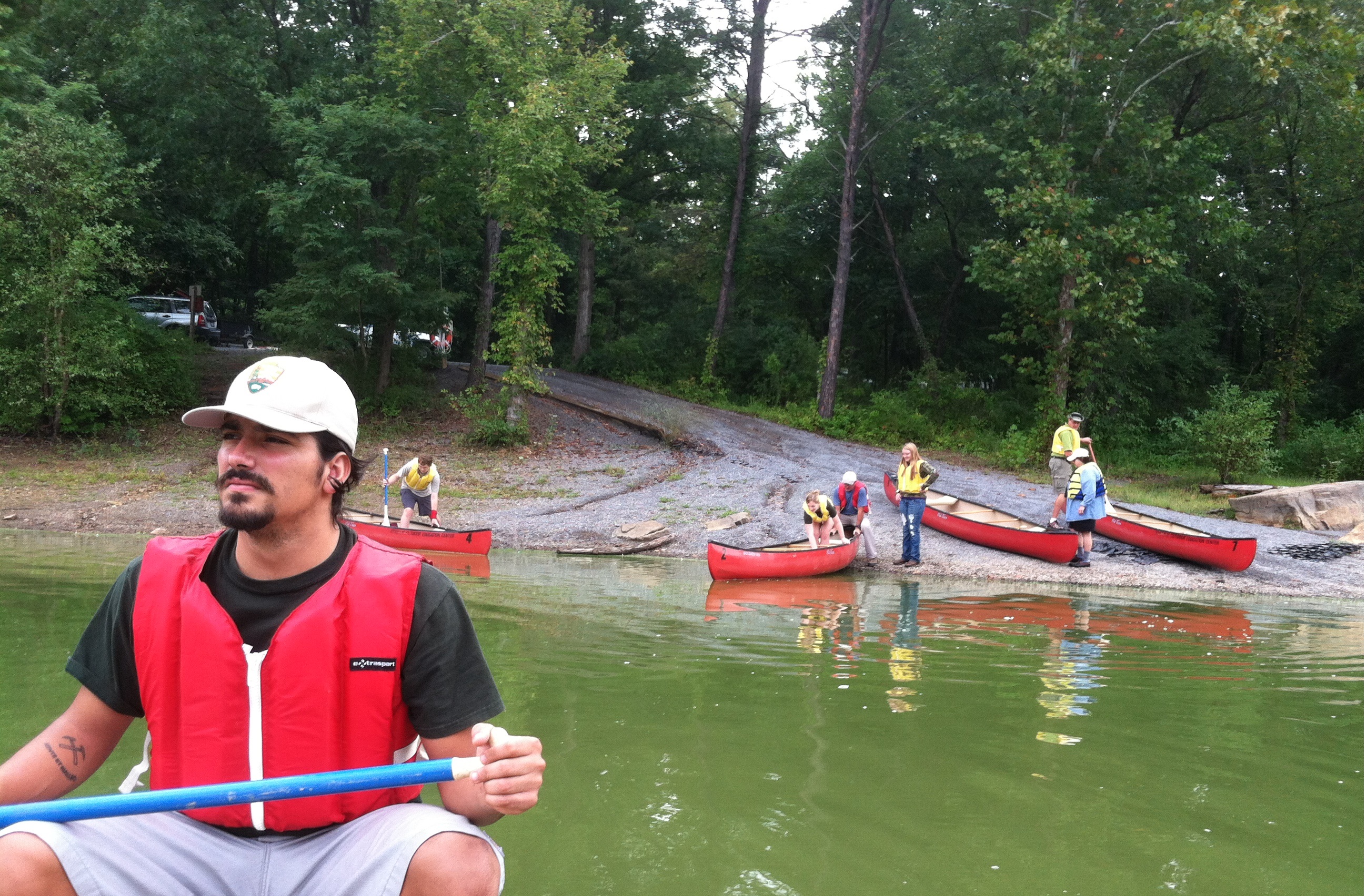
During my first mid-Atlantic summer, I was given the responsibility of aiding in the assessment of a wetland restoration site. Sometime during the 1800’s a farmer living along the Canal dug a trench that drained the surrounding wetland to convert the area into farmland. This area, known locally as the Chick Farm, was selected as a potential site for wetland restoration, but in order for any work to be done the Park needed to know how much of the wetland would be restored if the ditch was backfilled. After an extensive delineation survey of the entire site, the water table had to be continuously monitored. Every other week, I would go to the Chick Farm, record the location of the water table at each well using an electrical water level indicator, measure the height of each well, and record the data into a field notebook. The vegetation was so thick and thorny, it was difficult to spot the orange or pink DayGlo ribbons marking the wells! After each field session, I rubbed all exposed skin with half-a-bottle of TECNU and drove back to the office. All of the data was entered onto an Excel spreadsheet and sent to a couple of hydrogeologists in Boulder, CO for analysis.
My second Mosaics project involved monitoring fossiliferous outcrops along the canal in compliance with the Paleontological Management Plan drafted by previous GeoCorps participant Katie Loughney and National Park Service Paleontologist Vince Santucci. Because I am more familiar with paleontology and geology, this project was something I was much more comfortable doing. Protecting the National Park Service’s natural resources was one of my primary goals throughout my project and actively assessing fossil sites throughout the park was incredibly rewarding.

There are 27 in-situ fossiliferous outcrops along the C&O Canal, and many of them are a part of the Brallier Shale/Scherr Formation, the Foreknobs Formation, and Hampshire Formation located in the western section of the Park. Fossils in these outcrops are primarily shallow marine life from the Upper/Middle Devonian Period and include brachiopods, bivalves, gastropods, crinoids, and cephalopods. Other phyla from Cambrian outcrops along the Canal include trilobites and stromatoporoids. Because each outcrop is in close proximity to the highly trafficked towpath at the C&O Canal, there is a greater risk for fossil poaching and visitor impact threatening the viability of each site. Fortunately, or rather unfortunately, visitors are generally unaware of the paleontological richness of the Park, so crime and vandalism are generally uncommon. Outcrops are ranked on a standardized survey and can have scores that range from 0-170, with score above 90 meaning that the outcrop is in good condition and outcrops below a score of 50 are in poor condition. The Brallier Shale/Scherr Formation in particular contained sites with large fossil populations of mostly brachiopods and bivalves; however these outcrops tended to be very friable. This means that fossils are eroded away seasonally and that fossil collection should be conducted every other season or every year to preserve any lost resources. Most outcrops had scores in the lower 30’s, but a few were graded in the low 90’s. “At-risk” sites can be a bit worrisome because the C&O Canal does have a few interesting fossils including Archaeopteris, which is known as the oldest modern tree, and any loss of that particular fossil would be detrimental to the paleontological community.

GeoCorps/Geoscientist-in-the-Park (GIP) Projects
I’ve always had an intense passion for geology, and as a student I was very fortunate to have professors and mentors who equally shared this enthusiasm in the classroom. Since then, I have been inspired to share this fervor in a similar manner and to be at the head of a geology classroom. I was excited to learn towards the end of my Mosaics term that the C&O Canal NHP was offering a GeoCorps/Geoscientist-in-the-Park “Guest Scientist” project in geology and paleontology outreach and education. I applied through the GeoCorps website and had an interview. This extended my stay in Maryland for an additional 8 months, which meant that I would be living here during one of the coldest winters the area has seen in about a decade. It turns out that the cold and snow isn’t all too bad of a thing to happen as long as you have somewhere to play a little pond hockey.

Major Projects
My primary goal with GeoCorps/GIP has been to help increase visitor awareness of the Park’s geology and paleontology. The Park boasts beautiful outcrop exposures along the Potomac River, but their geological significance is often overlooked by guests. When I arrived, only one visitor center included a display that focused on the geology of the C&O NHP and I wanted to do my best to increase that number. In pursuit of this goal, I had to answer the question “Why should anyone care about the geology here?” Of course I was interested. I love rocks, but it was important to make the geology relevant to guests, which also had its share of caveats. The C&O Canal is 184.5 miles long and the geology and people vary along the way. The C&O Canal is special in that there is something for everyone here; some guests frequent the park for recreational purposes to rock climb, kayak, hike, or ride bikes, while others may prefer to fish in the Potomac River and wish for any federal agent to quietly get lost. It was important to think of new and exciting projects to make for each visitor center along the Canal, but it was also important for each new project to have a certain ‘hook’ that would draw public interest in the local geology. Trying to think of that hook proved to be one of the more important tasks of my GeoCorps projects.
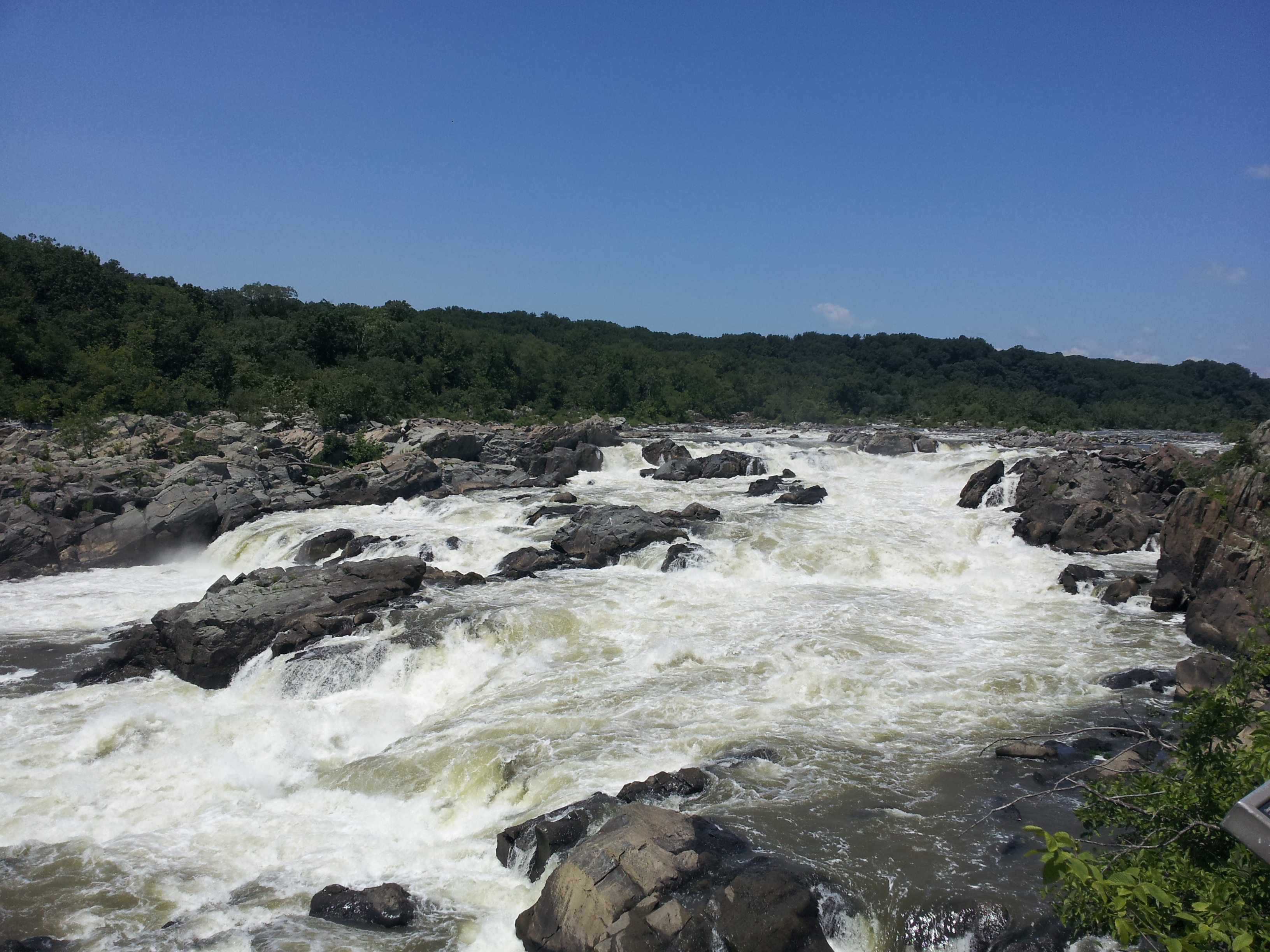
Great Falls, MD has some of the most fascinating and dramatic rock outcrops along the entire C&O Canal. The jagged cliffs and large boulders of the Mather Gorge Formation near the Great Falls Tavern Visitor Center, located in the eastern section of the park, are often frequented by hikers and rock climbers. Some of the most beautiful hikes in the mid-Atlantic are along Billy Goat Trails A, B, and C, in Great Falls, MD. During one of my visits to the eastern section of the park, volunteers expressed interest in learning more about the local geology. They often asked questions about the rocks along the Billy Goat trails, but the only answer one volunteer had readily available was, “Most of the rocks are mica-schist and meta-greywacke.” Obviously, visitors were interested in the geology here, so I started working on the Billy Goat Rock & Trail Guide –a trail map with numbered stops serving as an interactive geology lesson. Hikers will soon be able to pick up a trail guide and learn the geological history of the area by seeing the rocks first hand while hiking. Photos and interesting outcrop locations on a trail map will provide guests with a learning experience impossible to achieve in a classroom.
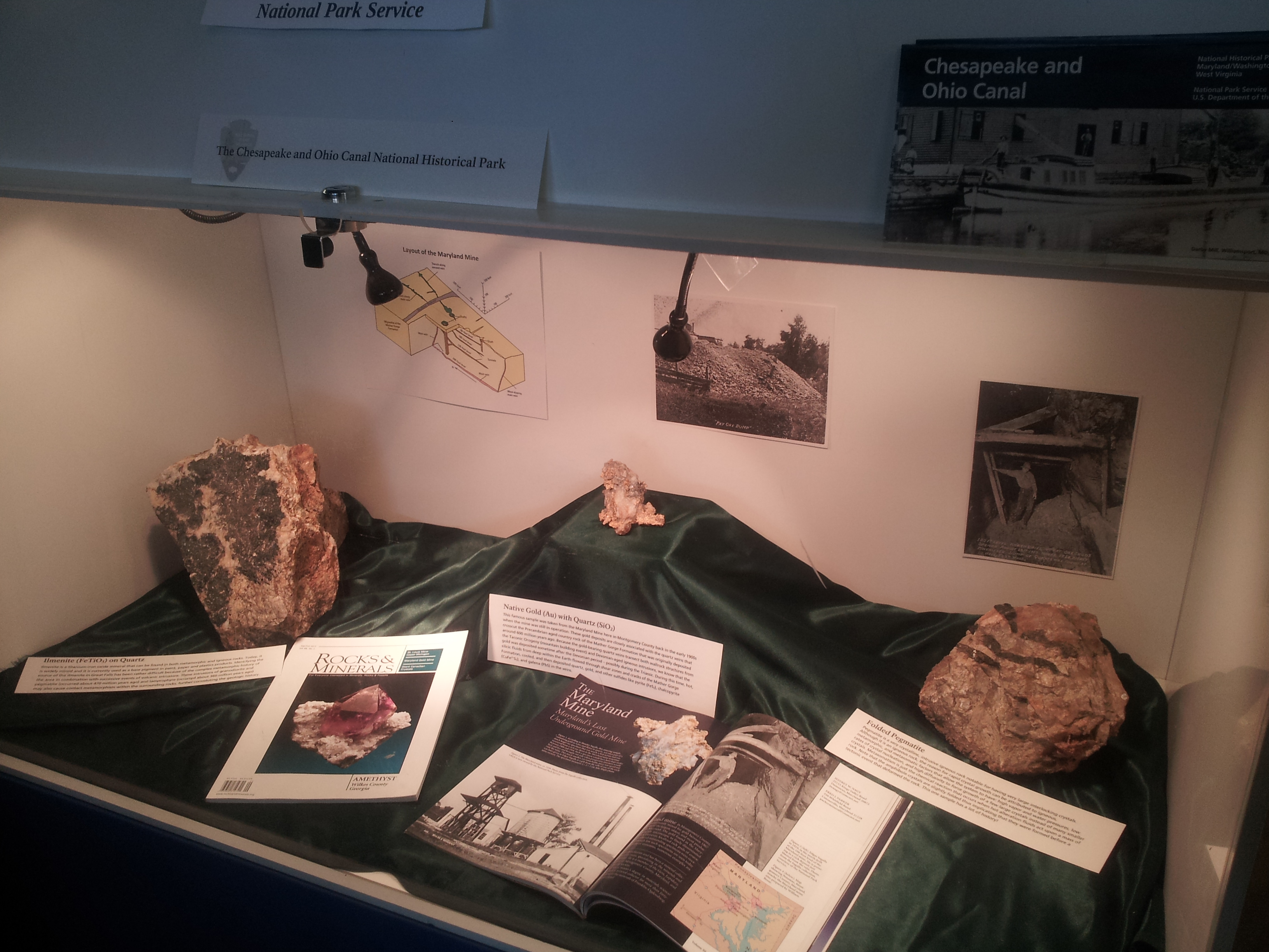
In addition to creating a new trail guide/walking geology lesson, I also started working on a new ore deposits display for the Great Falls Tavern and a fossil display at the Cumberland Visitor Center.
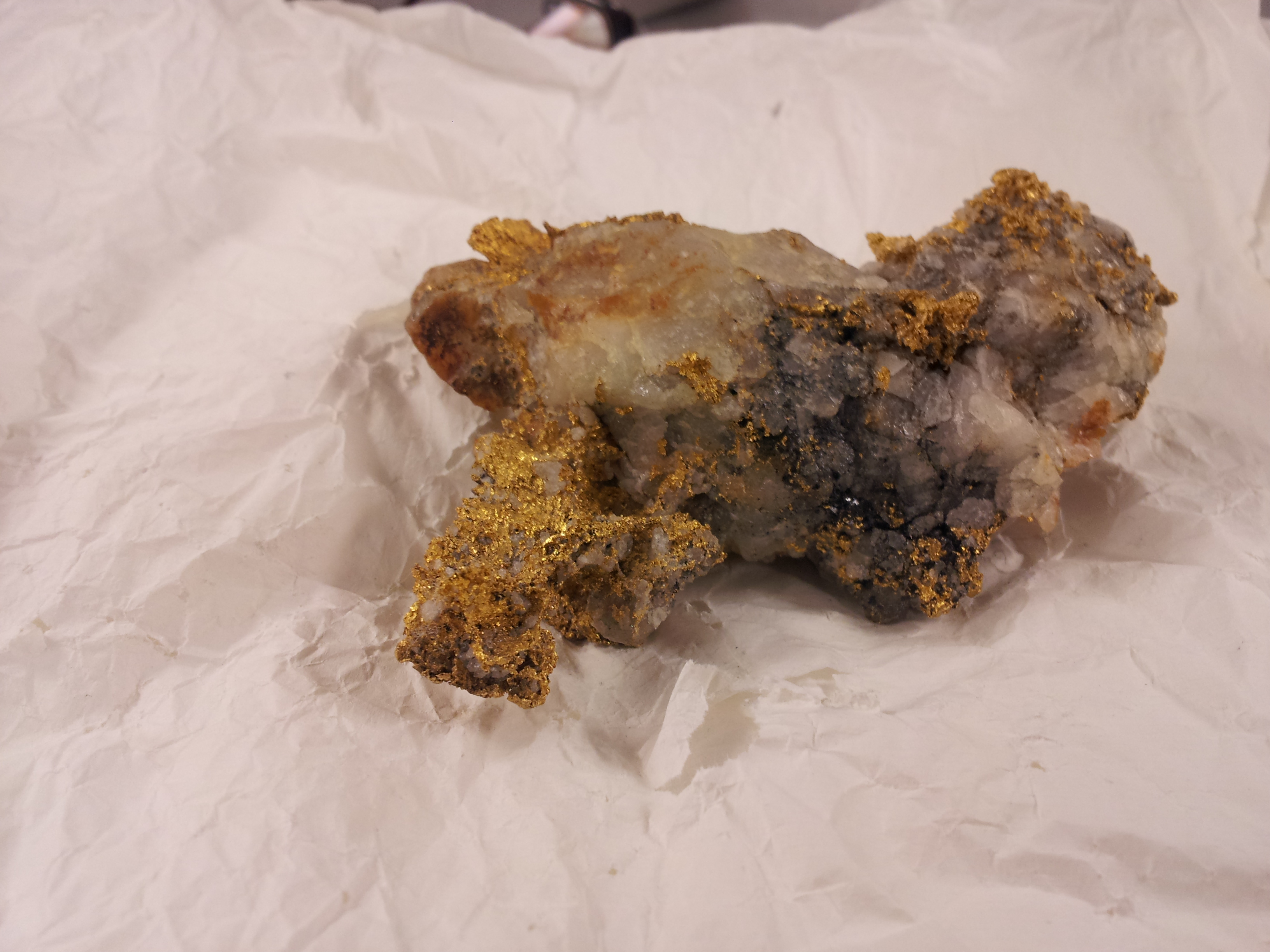
Gold mines attract a lot of interest from park guests who frequent the Great Falls area, but there aren’t any detailed displays or exhibits that show off the interesting mining geology of the area. The story of how gold was discovered in the area is pretty interesting. During the Civil War, placer gold was found by a Union infantryman who was washing skillets in the Potomac River. Shortly after this discovery, panning projects and mine shafts were established throughout Great Falls, leading to the opening of the Maryland Mine, among others. Gold was mined sporadically until the 1930’s with some mines staying open until the early 1950’s (Reed and Reed, 1970). The Gold Mine Trail along the C&O Canal takes guests on a tour of old mine ruins, so a display at the local visitor center explaining how the gold was deposited (along with some real ore samples), should be a big hit with tourists. The gold was deposited here as a result of numerous, complex stages of deformation and metamorphism that occurred during the creation of the Appalachians, which sent boiling hot geothermal liquids through shear zones and cracks of the Precambrian metamorphic basement rock, which then cooled and precipitated gold, pyrite, chalcopyrite, galena, and other sulfides.
Like gold and ore deposits, fossils also attract a lot of interest from guests, however the paleontological wealth of the C&O Canal is not currently known by many. The Cumberland Visitor Center is located in the western-most section of the C&O Canal in the Valley and Ridge Province, which contains fossiliferous rocks varying from Ordovician to Mississippian in age. These rocks represent the clastic marine and fluvial deposits of the Appalachian Basin (Southworth et al. 2008). Some of the fossils recovered along the Canal include trilobites, crinoids, brachiopods, gastropods, straight-shelled nautiloids, sponges, stromatoporoids, and many others. Often, children are exposed to paleontology through the fossils of boney fish, dinosaurs, and birds, with little exposure to the alien-like fauna from the early Paleozoic. That is why I started working on a new fossil display for the Cumberland Visitor Center and I started drawing a puzzle book for kids that focuses more on invertebrate paleontology. The idea behind this project was hatched by thinking about what I wish I’d had as a child when learning about fossils and ancient life.
In an effort to continue protecting fossil resources at the park, I have started working on a Paleontological Stewardship Program with Vincent Santucci of the National Park Service. The C&O Canal is unique because of its dimensions, but because of its great length, it can be very difficult for law enforcement to manage. Although there is no current evidence to suggest that park guests have illegally removed fossils or other related resources from the premises, the recent effort in geology and paleontology outreach could potentially lead to fossil poaching by curious park guests. The adage that “we will conserve only what we love” is sadly, yet inherently, true which is why education efforts at the Park have increased through my GeoCorps and Mosaics work. With a new Stewardship program, the Park will be able to train volunteers and have them monitor various fossiliferous outcrops for any unwanted damage. If anything is reported, then law enforcement will be able to increase patrols in the vicinity. Hopefully the new fossil display at the Cumberland Visitor Center will give the public the sense of duty to maintain and conserve the natural resources that are located in their own communities.

Reflections
At the beginning of my work with Mosaics in Science and GeoCorps America, I knew I wanted locals to be proud of their National Park. The C&O Canal is quite literally in the backyard of so many people throughout Maryland and West Virginia. The Canal is incredibly important in understanding the geological history of the Mid-Atlantic as outcrop after outcrop can be spotted along the towpath that snakes down through the Coastal Plain, the Piedmont, the Blue Ridge, and the Valley and Ridge Provinces. Along those 184.5 miles, rarity after rarity can be found, whether it is an Archaopteris fossil that has been trapped in a piece of shale for hundreds of millions of years or even the lamprophyre dikes that cut through the jumbled metamorphic complex of the Mather Gorge Formation near Great Falls, MD. I want people to be excited about the geological features at the C&O Canal NHP, and I want them to learn more about them. After my projects are over, I want people to view the towpath as something more than a recreational trail; I want people to use the towpath as a classroom to explore nature and geology. All we have to do is show the people why their Park is interesting. In my attempt to complete this vision, I also got to know more about myself.
I took a chance to move across the country to a place I had never heard of to work for a Park I knew nothing about, and in the end, I feel that it was definitely all worth it. I met true friends during my stay who have been nothing but supportive, kind, and loving to a once-total stranger that moved into their small community. I experienced the true satisfaction that comes at the end of a hard and honest day’s work, spending some days and nights working after hours hunched over a computer screen putting the final touches on a poster, drawing, or report. Working with others in developing a plan to protect paleontological resources at a National Park was an incredible experience, and the scope of the project was much larger than anything I had ever worked on. I was in charge of site selection and setting up training procedures, and had so much responsibility for the project that it felt like something that was truly ‘mine.’ I’ll never forget my time here in Maryland, all the friends I made at work and in Shepherdstown, and I know that I always have a friendly place to visit if I am ever in the area.
I could not have learned so much about myself and about working as a geologist without the help of the Geological Society of America’s Mosaics in Science program. It opened the door working in a GeoCorps America/Geoscientist-in-the-Park project. It’s been a wild ride.
Works Cited
Reed, J.C., Jr., and Reed, J.C., 1970, Gold veins near Great Falls, Maryland: U.S. Geological Survey Bulletin 1286, 22 p.
Southworth, Scott, Brezinski, D. K., Orndorff, R.C., Repetski, J.E., Denenny, D.M., 2008, Geology of the Chesapeake and Ohio Canal National Historical Park and Potomac River Corridor, District of Colombia, Maryland, West Virginia, and Virginia: U.S. Geological Survey Professional Paper 1691, 11p., 1pl.

Back in 1970 I too discovered the C&O. I was a night law student working at the Patent Office during the day, and so in order to fight a case of terminal “flat butt” syndrome I turned to biking the Tow Path and nearby countryside. There were many great rides, even during the hoternhell summer, my favorite being up to Panther Springs and the Antietam battlefield with return to Arlington. In those days you could even see old Justice WO Douglas, guiding father of the Park, with his thirty-something girlfriend, hiking the towpath with the legions of appreciative users.
Your writing is quite good and your enthusiasm is shared with this old-timer. Carry the torch!
How does one find opportunities like these?
Hi D, Ivan participated in two programs of the Geological Society of America (GSA):
1. Mosaics in Science – http://www.geosociety.org/mosaics
2. GeoCorps America – http://www.geosociety.org/geocorps
If you have questions about these programs, please contact geocorps@geosociety.org or mosaics@geosociety.org
Best wishes,
Matt Dawson, GSA
Glad to hear of your continued success out east, Ivan. I need to get my hands on one of those paleo puzzle books! Now, what is next for you?
You make me proud to be from Maryland.
Good post. I learn something totally new and challenging on sites I stumbleupon every day.
It will always be helpful to read through articles from other writers and use
a little something from other websites.
Very well done Ivan! You are an exemplary public servant and a great writer too!
Wow, that is incredibly kind of you to say. Thank you!
Really nice blog, Ivan. It’s great to hear what your year has been like – and better than you even expected!
Thank you Dawn, I am glad you enjoyed it!
Great story, Ivan. And a great start to your career as a professional geologist. Go to grad school next.
Thank you Dave. Graduate school is the next step!
Good job Ivan!
What a wonderful story! Makes me want to visit and see this region, it’s beauty and rich history.