Haakon Fossen is a structural geology professor at the University of Bergen, Norway. His website is http://folk.uib.no/nglhe/
I grew up among (proto)mylonitic gneisses, LS-tectonites and other strongly deformed metamorphic rocks in the Caledonides near Bergen, Norway. This was all normal to me, and the first rock that caught my attention, as a kid, was an ultracataclasite. Flinty and pointed as the rock was, I wondered if it could be a tool or arrowhead, but having given up that theory I somehow figured out that it could be a mylonite, and later that it was more appropriately to be named ultracataclasite. I soon came to envy others who had the opportunity to see less deformed rocks, particularly sedimentary rocks. And the rock that, at the time, stood for me as the most exciting one of all was – conglomerate.
I was 16 or 17 years old before I had the pleasure of getting close to a conglomerate. I remember it as a great moment – Silurian conglomerates in what I later learned to be part of the cover sequence to an ophiolite complex. But an even more awesome moment was to come a few years later. A beautifully deformed conglomerate (Fig. 1) turned out to be located in the mountains near Bergen, and I was totally blown away by the beauty of these strained rocks. I think the concept of deforming anything as hard as quartz like it was soft modeling clay was what really turned me on. There was little doubt in my mind; structural geology was the way to go, and the observation of naturally deformed rocks in the field was what triggered it.
And by this I have reached the main point of this blog article; field observations. Field observations and fieldwork have been an important aspect of structural geology for me ever since. It is a necessity, a condition for life as a structural geologist the way I experience it. Physical and numerical models are indeed both interesting and useful, but they cannot replace the joy and importance that comes with real rocks and making your own field observations.
At the same time, the large number of models and interpretations that can be made from field observations, the large degree of freedom if you like, sometimes makes it frustrating to be a structural geologist. It is a well-known fact that a model that explains a given set of data does not have to be correct, simply because there may be other, usually many other reasonable models that fit the data equally well. Just think about infinite number of strain paths that conglomerate pebbles can follow to reach a given state of strain. From my own experience it seems that we tend to become more aware of this fact as we gain experience as geologists. And as this happens, it becomes even more important to go back to the rocks and outcrops to look for more clues through new observations and descriptions. This pushes me back to my first thrilling encounter of beautifully deformed conglomerates. Back to the roots, back to enjoying the beauty of deformed rocks, to observing and describing. And it feels right.
Don’t forget to bring your sketchpad
Let me immediately admit that I spend too little time drawing and sketching while doing fieldwork. It is just too easy to hit that camera button and leave it with that. Don’t get me wrong: the camera is my best friend in the field. But sketching, and the visual aspect of structural geology in general, add to the quality of fieldwork for several reasons. Not only does sketching allow us to better capture the aesthetics and beauty of structures and deformed rocks (which is important in its own right), but it also enables us to capture more of the details, details that may be extremely important in how we understand or interpret their formation and evolution. A field locality should always start with a sketch. Sketching and drawing takes our observation ability to a higher level. The information that can be extracted from outcrops through sketching is amazing, almost regardless of the observer’s drawing skills.
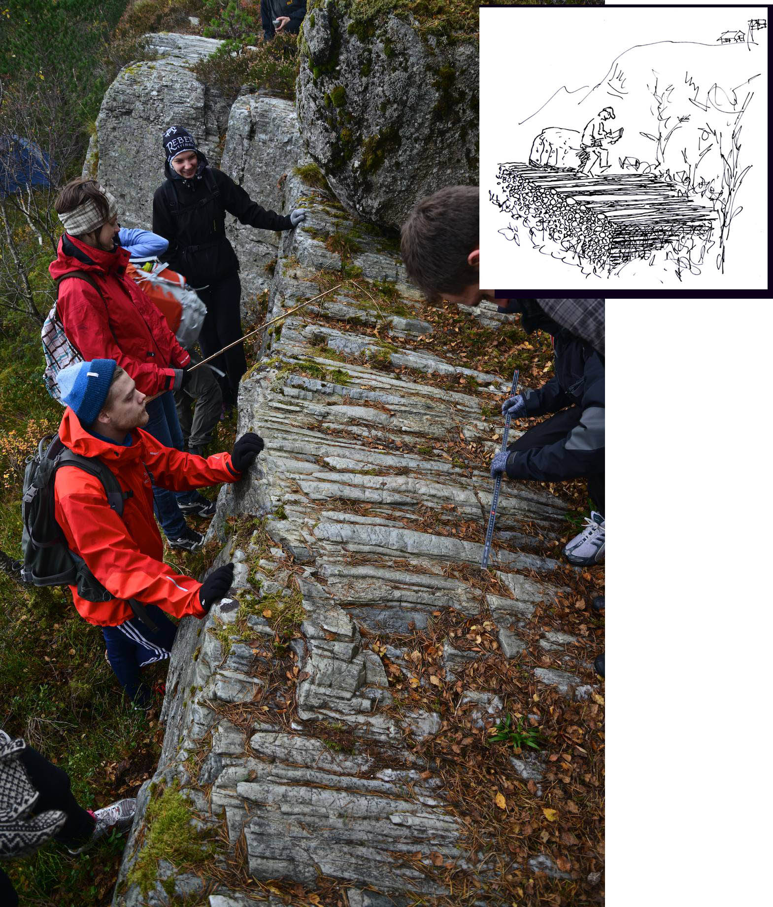
My students, like most other students, are exposed to “the sketching experience” during field courses (Fig. 2). They are “forced” to sketch up the outcrop that they are about to examine. I hear the phrases such as “but I’m a really lousy drawer” or “my drawing skills suck”. But my students (and I too for that matter) often times get really surprised by what they get out of 10-15 minutes of sketching in the field. The difference in the level of observation between students who do and do not spend time sketching is remarkable.
Then, once they discover the usefulness of sketching, the next thing that comes up is a request for a course in drawing techniques. Why do hardly any geology departments offer such courses? I guess some departments have skilled field instructors who teach some of the basics of field sketching, but few do this in a systematic way. If a field-oriented drawing course for geology students exists, then I would really like to know more about it. Interestingly enough, a student recently asked me if I would be kind enough to run a little workshop on field sketching, and lacking any good alternative teacher for such a class in our department, I reluctantly agreed. Well, the student posted it on Facebook, and after a day or two more than 100 students had signed up for it! It is happening this week, and students voluntarily come in to the U at night to spend time on this no-credit mini-course.
What I am trying to communicate is that there is obviously a need and desire of both undergraduate and graduate students for this kind of teaching. Perhaps North American universities with their extensive field camps (see previous blog essay by Peter DeCelles) manage to put this into their curriculum in a better way than we do – it would be interesting to know how North American students think about this (please post comments!).

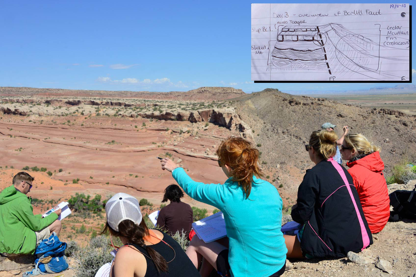
Comparing sketches and techniques is also interesting. Some prefer 3D sketches, while others are more comfortable working in 2D, producing cross-sections and map-view illustrations (Fig. 3). Some try to capture (sometimes too many) details, while others make very general or idealized sketches reminiscent of textbook or article illustrations typically found in early- to mid-20th century publications.
I believe that students (and their professors too) learn more efficiently if they engage “both sides of their brain”. Just taking a picture does not match the on-site sketching experience, but I have found that spending some time on location and then additional time on my computer drawing sketches based on photos has some of the same effect; tracing or sketching from a high-resolution picture forces you to explore structural complexities and relative age relations, and that process in itself may be quite rewarding, in spite of the many limitations of a photo.
We see what we are trained to see
What we are talking about here is all about learning from rocks, about extracting information from outcrops. One of the dangers involved in this game is the fact that we see what we are trained to see. We use textbook and lecture examples as references or “standards”, and we automatically try to force what we see in the field into those models. I guess you could say that we are all brainwashed to some extent. This does not mean that you should throw away your textbook – it’s just something to be aware of. Ideally, observations and descriptions should be our starting point, while presumptions and existing models should be secondary.
Let me share an example. During my PhD I did structural mapping in a part of the Caledonides where well-foliated protomylonitic rocks had been pervasively folded into asymmetric hinterland-verging folds and shear fabrics. These folds are extremely prominent and really eye-catching (even in the winter, see Fig. 4), occurring from microscale structures to kilometer-scale asymmetric folds. Still, the structural geologist who mapped the area and wrote two healthy books about the structural geology of this area hardly mentioned their existence. I suspect at least part of the reason was that the folds did not fit the general concept of foreland-directed Caledonian thrusting, and therefore were largely overlooked. The message here is that if you force yourself to sketch out the details of key exposures, you also force yourself to deal with the structures that are there.

The discovery of S-C and related kinematic structures found in shear zones and mylonites (Fig. 5) may serve as a more general, albeit related example. Detailed field-based descriptions were what made us realize that these structures relate to strain partitioning during shearing rather than representing classical crenulation cleavage. Shortly after the publication of some key papers on this issue, S-C structures were discovered in shear zones all over the world. The implications of the kinematic information that this provided were enormous, and helped among other things to distinguish between extensional and thrust-related detachments. It was also a valuable tool for me as a student, as it helped to link the aforementioned hinterland-verging folds and related shear fabrics to post-collisional extensional reversal of the basal décollement of the Caledonian orogenic wedge, and to relate this extensional deformation to plate-scale divergent motions.

The interesting question is whether there are other secrets hidden in rocks, secrets that we are missing out on because we are too caught up in our preferred models and entrenched ways of thinking. Are there other simple and, once understood and pointed out, intuitive, easy-to-use structures that we need to discover? Or will future advance in our field solely rely on more indirect methods, such as sophisticated isotope or geophysical data?
Regardless, the importance of objective observations through field sketching and descriptions will always be important, making the foundation for more advanced secondary work. Hence we should keep training our students (and develop ourselves as teachers) in this important part of geological research.
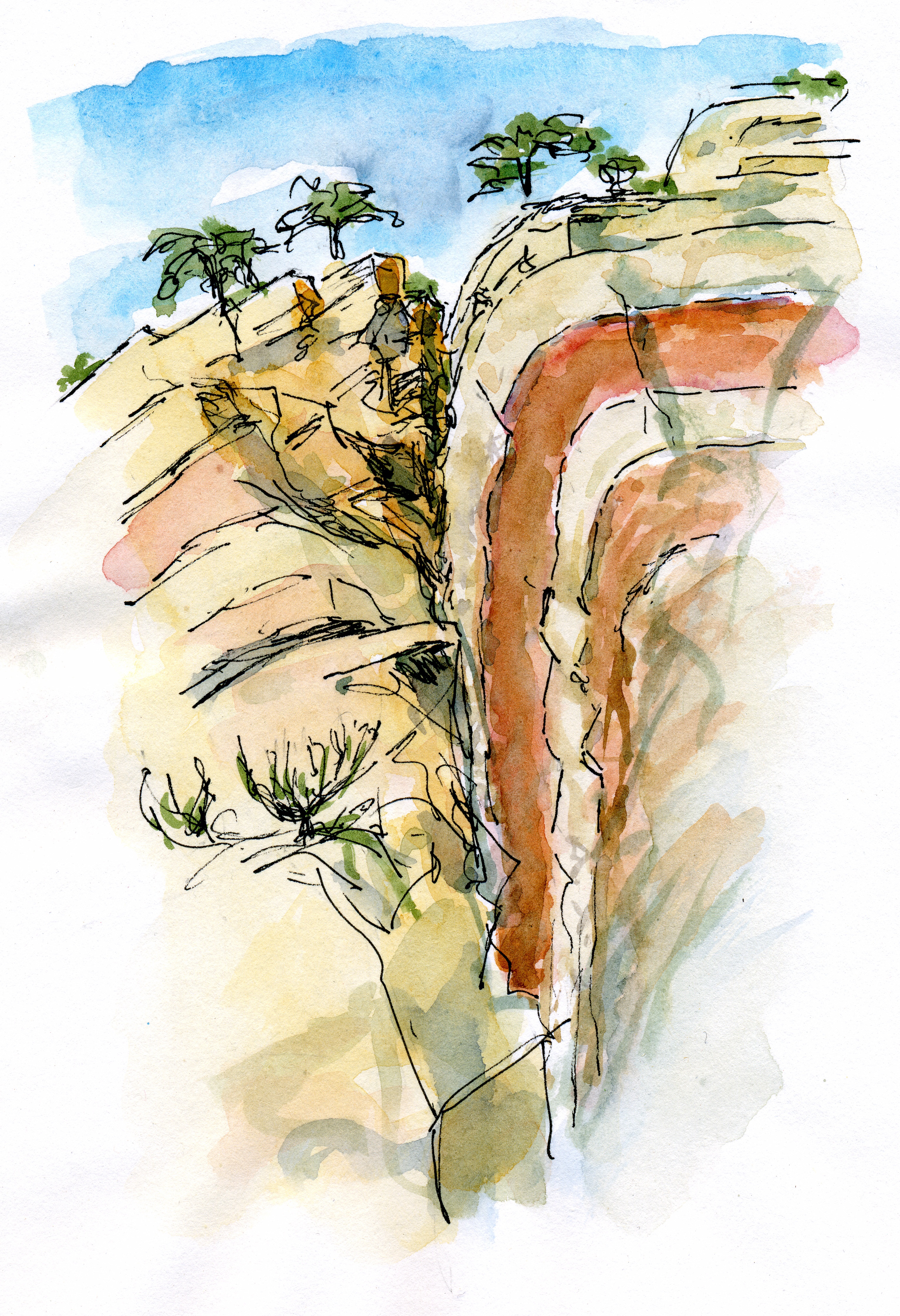
But it’s not only about research. Spending time in the field, observing, drawing, coloring (Fig. 6), geo-contemplating and perhaps enjoying a bit of a workout as we move around in the field while being away (?) from our computers and email provides rest and nourishment for our geologic souls. It brings us back to the joy and excitement that we felt when we first discovered an awesome fold, some beautifully deformed fossils or, as in my case, an intensely strained conglomerate.

geosketches are for life, not just for the field season….
I just discovered this posting after it was linked by a LinkeIn Contributor. I’m utterly in agreement; a bad sketch (if that’s all you have) beats a wonderful photograph (if that’s all you have), because you had to look carefully at the outcrop in order to make the sketch, and that makes you observe things you wouldn’t have noticed otherwise. It also helps you to remember it and put it in context. And at the end of the day, you have a note book full of your thoughts, as opposed to a hard drive full of nice photos (but you often can’t remember why you took them!). And I would go further – just about any geological concept can be expressed as a sketch, whether it’s an outcrop, or an idea someone presents in a meeting; the act of drawing it helps you understand what you heard and saw in the meeting in the same way that it helps you understand what you see in an outcrop. So I carry round a big hardbound sketch book at all times, and now I have a chronological record of all my thoughts over several decades in the oil industry and my new life as an academic….. mostly in the form of skecth cross sections and block diagrams.
Regarding Haakon’s original posting, I am entirely in agreement that there is huge value to making a sketch and I value the continuing discussions. One should however also take lots of detailed close-up photos, because you never know how your interpretation of that outcrop will change over time. The digital camera has changed everything. Maybe you will see things you didn’t even know about before. As an example, in the Ontario Geological Survey reports from the 60s and 70s, spinifex was called “chicken track” texture and attributed to metamorphism. Now, we can look at these photos and actually tell facing directions. This is possible because of brilliant sleuthing done much later. Would you have seen the subtle foliation or brecciation which marks flow tops when you were sketching?. Would you have stripped the outcrop of moss to look for critical features to sketch? And then, how much time do you want to spend sketching? The helicopter, which costs $1,500/hr is idling beside you on the mountain top, ready to take you to the next stop!
This is a most interesting discussion. Careful detailed outcrop mapping of trenches and seashore exposures and reinterpretation of the significance of quartz in turbidites textures has re-opened the field of syngenetic formation of lode vein gold deposits. The problem is that as Haakon has pointed out, presumptions and existing models. Two geologists with different backgrounds can interpret the same outcrop in a diametrically opposed manner. Actually, the problem starts even before then, because you will sketch or describe what you see. I once sent a student to a gold showing, exposed in a trench, asking him for a one page description. He came back with a deformation alphabet, but failed to mention what was the host rock. He had an MSc degree from a prestigious Canadian university……..so probably minimizing your presumptions is as important as maximizing sketching skills ,
I can comment from the other side of the brain! As a full time artist who has done a diploma in geology – I loved the field sketching but found it as frustrating as everyone else. There are really two main things that came in handy as an artist.
First, the ability to start drawing at the right scale. Basically – knowing that when I reached the endmost area of a landscape it wasn’t going off the page. Of course, I didn’t always succeed anyway. 😉 For this I’d say start some sketching along with the geology approach of taking in the whole field of view first for context. Mark your endpoints and do a very simple basic overview of your entire area. It could just be a basic line of the topography. Or if drawing a feature do a quick vague outline of the whole thing first – then fill in the major features, then details. This helps keep it all to scale.
Second, and the tricky one, is the “draw what you see, not what you think you see” concept. You’ve already identified this with “we see what we are trained to see”. Perhaps it’s reassuring to know artists have exactly the same problem. Artists know their objects, bodies, landscapes and can be tempted to draw an ideal from experience. Then wonder why it doesn’t actually look right in the end! Sometimes on my field trips I would draw whatever was there, even if it made no sense or looked wrong, or I knew I was missing something (from my lack of experience). Correlate it with other information later.
Really, the way most artists learn to draw is simply by drawing more. Find the tool you like (a pen is as valid as a pencil or an iPad stylus) and just draw over and over again. Make mistakes, start over, don’t be afraid to scribble out a bit, don’t worry about an eraser. I now just have a shorthand technique of Xs to indicate which part of the drawing are wrong, that I use a lot in my astronomy observation drawings too.
Funny, we approached our Structural/Tectonics professor about just such an idea, a sort of basic “scientific drawing/ field sketching” seminar or short course. It always seems to be received as “a neat idea” but not a priority. It’s vital to capture and communicate your observations gathered in the field; sketches and cross sections were a great way for me to organize my observations, manage my time and focus, and be able to back up my interpretations.
The gigapan idea seems like a great way to introduce the basics before piling into the field; I’d love to hear more about how that was implemented.
I used to teach at a small liberal arts college in Wisconsin. My field methods students, too, had asked me for instruction in how to sketch. One year when I was heading to GSA, I took advantage of my time away by having one of my art department colleagues teach my class that week. We met in advance to discuss what makes a good field sketch. He built his exercises around those goals. The students loved it, and their field sketches on our next trip were vastly improved.
Wow, that sounds interesting. It would be great to hear more about what you figured out as far as what makes a good field sketch!
I remember that he translated my thoughts into the terminology he would use as an artist. I started by showing him some of my field sketches from a recent field trip and talking about what information they recorded for me.
Two things that I value in field sketches are proportionality (it doesn’t have to be perfect, but it helps to have things drawn approximately to scale, and especially preserving angular relationships) and that the geologically important features are emphasized. That’s a bit tricky, of course, because what’s important is a matter of interpretation, and to some extent I also want my field sketches to just record observations. But certainly sketches ought to record whatever structural features I observe (bedding/cleavage intersections, or shear sense indicators, or whatever). We talked about various ways to emphasize that information, including having some sketches of the details of smaller areas of interest.
I think that for my students, at that time, the most helpful advice he had was on how to keep things in proportion. Mastering that allowed them to do a better job of recording visual information in general.
Good points. Thanks for sharing. I think there are different approaches to field sketching, depending on the purpose. Sometimes you really want to emphasize a certain structure or feature, toning down other (distracting) stuff. Other times it may be useful to just sketch up anything that might be geologically relevant, being true to the outcrop, and see if it leads to new observations. Proportionality may be important in any case, and adding actual angles and orientations measured in the field may add to that (since angles are not always what they seem to be, depending on perspective).
I consider my drawing skills to be pretty lousy, and my early field sketches were pretty atrocious. Eventually I realised it’s not about making a pretty picture of what’s in front of me, but more about making a schematic sketch to pull out the features which are hidden in the rock. I’m never going to accurately draw all the boulders in a conglomerate bed, but if my sketch can capture the general morphology of the bed, the shape, size, and composition of the boulders then that will be good enough!
I also find sketches are great for getting you to sit down and forcing you to look at a outcrop at every scale. You don’t know if you’re missing anything if you just take a quick look and don’t see it.
Nowadays I really enjoy a good field sketch of a really exciting outcrop. A photo just can’t capture everything that you see!
I agree – thanks.
Among the benefits of training in life drawing techniques, which include outdoor landscape experiences, is developing facility of eye-hand coordination and visualization. Many people are mystified by the ability to render images, yet understanding how to assess the relative sizes and shapes of pictorial space is a teachable skill, useful not only for geologists. Even children can develop these skills, and preferably before they develop self conscious censoring. There is much mistrust in developing the life of the imagination, and fewer educational opportunities is the result. As a visual artist and educator, I’m impressed by your students’ interest and enthusiastic response to your workshop.
You ask about a field-oriented drawing course for geology students. I use gigapans of geological structures (e.g. http://gigapan.com/galleries/4723/gigapans/84830) to train students at home and in class their drawing skills. And it works. Once in the field you see that they benefit of this drawing excercises.
Gigapan is great because of the ability to zoom in on details. I wonder how exactly you use it? Do you give them specific exercises where they use their own computer (so that they can zoom in/out individually)? It would be interesting to hear more about your experience with this.
Great post. This takes me back to rigorous classical field camp education many of us went through in the past and experienced the wonders of geology in natural setting. You highlighted the significance of such exposure and the value associated with field mapping techniques as these pertain to imparting hands-on and critical thinking undergraduate education through beautiful illustrations. For geologists, field experiences are deemed by many as the central thrust when it comes to successfully explaining the origin of a terrain. Thank you so much for bringing importance of field geology education with the help of text-book quality outcrops characterized by deformed, complexly folded, faulted and other geological features. Enjoyed it very much.
I am a recently graduated North American geology student who attended a university with very limited resources, and thus, probably missed out on learning opportunities most students at larger schools could take advantage of. Therefore, my exposure to field work, and sketching techniques in general, was limited. I did try to attend every field trip to gain experience, and I also attended a six week “field camp” course in the front range of the Colorado Rockies. Through all this, my professors impressed upon us the necessity to sketch what we see, but failed to spend any significant time teaching us “how” to sketch what we see, in order to capture the important parts of an outcrop. As a result, I feel that I missed out on a vital aspect of learning to be a geologist. If there had been a class like the one you spoke of, I’d have certainly attended, whether it was a credit earner or not. I’m grateful for professors like you who understand the importance of the “little things” in geology, for it’s not enough to simply explain the geologic processes that have shaped an outcrop, but one must truly “see” the results of those processes in order to better understand and imagine the processes themselves. Do you continue to offer the class, as I would be very interested in enrolling. Thank you.
Thanks Leah! It’s great to hear from fresh geoscientists about things that they enjoyed and would like to see improved about their recently completed education. I think many of us, professors and students alike, wish we had actually learned how to do field sketching rather than just being told that it is important. I definitely think this should be given attention during a six week field course. Something to think about for those of us teaching field camp?