by Joann M. Stock
This essay discusses one of my favorite field photos (Figure 1) and how it relates to the tectonics of the Pacific-North America plate boundary in the Gulf of California. I like this photo for two reasons. First, even people who don’t know much geology can usually pick out the faults in the picture. Second, the rocks and their relationships in the photo have important implications for Miocene paleogeography and development of the Gulf of California rift.

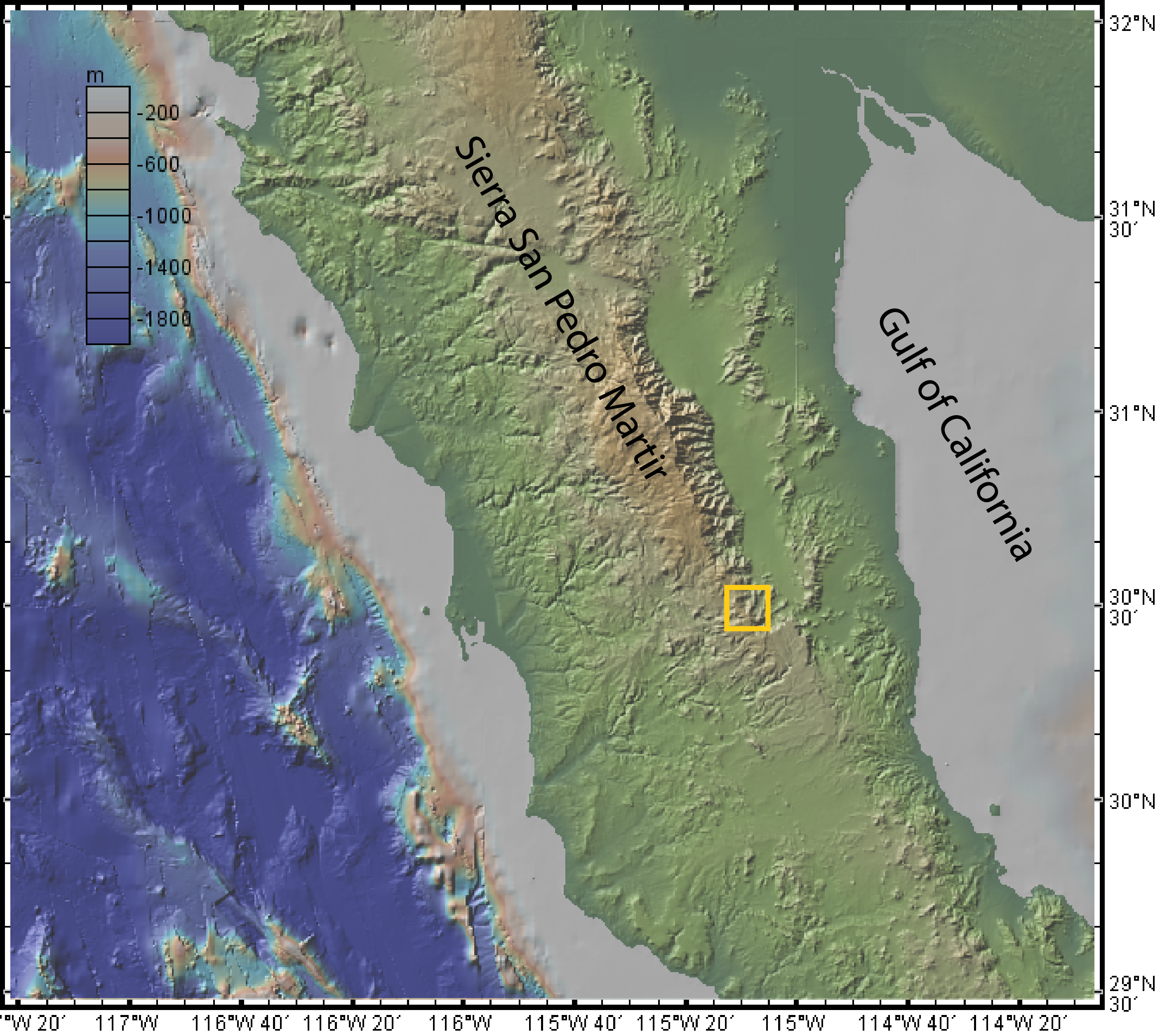
The photo looks northwest at part of the Main Gulf Escarpment, which is the boundary between the unextended Peninsular Ranges of Baja California, on the west, and the tectonically extended mountain ranges within the Gulf of California Extensional Province, on the east (Figure 2). North of the region of the photo, the Main Gulf Escarpment is controlled by the E-dipping San Pedro Mártir fault, which has an estimated normal offset of at least 5 km and a Holocene scarp about 80 km long that controls the very sharp, scalloped eastern edge of the Sierra San Pedro Mártir mountain range. At the region of the photo, the escarpment is formed by a series of faults, including those shown in the photo and some further east that are to the right of the scene in the photo – see map by Stock (1993).
Most of the rocks visible in the photo are tonalites of the Cretaceous Peninsular Ranges batholith (e.g., Ortega-Rivera, 2003). The flat package of rocks, overlying the batholithic rocks, includes: a recessive basal layer of nonvolcanic sedimentary rocks, cliffy layers comprising conglomerates, tuffs, andesites, and lahar deposits derived from the early to middle Miocene subduction-related volcanic arc which lay to the east; and finally a ca. 12.5 Ma mesa-capping pyroclastic density current deposit (high-silica rhyolite, peralkaline ignimbrite) which Stock et al. (1999) correlated around this part of the Gulf Extensional Province and named the Tuff of San Felipe. The relationships in the photo, borne out by regional work, suggest that there was a low-relief erosional surface on the batholithic rocks at the time of deposition of the early to middle Miocene arc rocks. Regional mapping indicates that the faults postdate the volcanic deposits and that there was no topographic escarpment here when the Tuff of San Felipe was deposited (Stock et al., 1999).
The Tuff of San Felipe has now turned out to be a much more widespread unit than we ever expected when it was first documented in Baja California. It apparently cooled during a magnetic field transition or field reversal, fortuitously acquiring a very unusual direction of remanent magnetization, shallow and slightly up, towards the SSW. This unusually shallow paleomagnetic direction, along with the unit’s macroscopic characteristics (crystal-rich, with many lithic lapilli and a distinctive basal vitrophyre), its crystal content: 5-15% alkali feldspars, Fe-rich clinopyroxene, fayalite, Fe-Ti oxides, zircon (Vidal-Solano et al., 2008) and geochemistry (Vidal-Solano et al., 2013), allow detailed correlation of the outcrops in the region. After correlation, the differences in declination of the remanence direction constrain the rotations of the crustal blocks (e.g., Lewis & Stock, 1998; Oskin et al., 2001; Oskin & Stock, 2003; Bennett & Oskin, 2008; Bennett et al., in press).
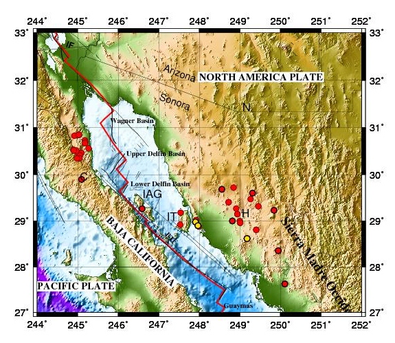
The Tuff of San Felipe has now been correlated much farther than the mountain ranges in Baja California where it was initially identified – despite its problematic content of xenocrystic material complicating the geochronology (Vidal-Solano et al., 2005). Outcrops have been identified farther north, west and south on the Baja California peninsula (Bennett and Oskin, 2008; Olguin-Villa, 2010) as well as on the major Gulf of California islands (Tiburon Island, Isla Angel de La Guarda), on the eastern side of the Gulf, in coastal Sonora, and in quite a few mountain ranges farther inland in Sonora (see red dots and yellow dots in Figure 3)(e.g., Martin-Barajas et al., 2008; Vidal-Solano et al., 2005, 2008; Olguin-Villa, 2013). The identified outcrops are distributed over a distance of about 450 km; the edges of the deposit are not known. About 260 km of the distance can be blamed on the subsequent opening of the Gulf of California and a bit more on the extension in the Gulf Extensional Province in Baja California and Sonora. Even so, it seems that this pyroclastic density current reached more than 100 km from the vent, in several different directions. The volume of densely welded Tuff of San Felipe calculated from the Baja California side alone is about 125 km3 (Sabbeth & Stock, 2012). This suggests a Volcanic Explosivity Index of 7, which is why we refer to this as a mega-eruption.
So what does this have to do with the Gulf of California rift? The pyroclastic density currents from the mega-eruption blanketed a low-relief landscape, and traveled in some alluvial channels, at a time when there was no rift topography or rift-related rocks here. The tuff it left behind was, to first order, a widespread flat horizon that now serves as an unusually precise structural marker for all the rift-related vertical motion and rotation on both sides of the Gulf of California since ca. 12.5 Ma. Where the Tuff of San Felipe is preserved, it records how much differential uplift has occurred since the eruption (e.g., 1.6 km in the region shown in Figure 4) – a very important observational constraint for any geodynamic models of the development of this part of the rift. Ongoing field work in Sonora is building the equivalent picture there for vertical motions and rotations, although outcrops are not as continuous because of the extensive younger cover in the coastal plain. Note that from the Tuff of San Felipe alone, we can’t tell when the rifting started, but 6.1-6.4 Ma volcanic units here, near both shorelines of the Gulf of California, were deposited in a nonmarine setting and match back together after restoring about 260 km of opening across the basins of the northern Gulf of California (Oskin et al., 2001; Oskin & Stock, 2003). Many Mexican and US investigators have done a great deal of additional work to further our knowledge of the evolution of the Gulf of California, and there are more interpretations and controversies related to that, which will have to wait to be discussed some other time.

Many questions remain about the scenario of the mega-eruption. Two vent locations separated by about 100 km are under investigation (Fig. 3). The probable vent location near the Sonoran coast is extensively dismembered by faulting, requiring more field work to determine its dimensions, and look for a caldera caused by the eruption. Recent geochemical results (Vidal-Solano et al., 2013) favor the model that the two vent locations were originally very close together and are now offset right-laterally along a strike-slip fault. We might expect the mega-eruption to have produced a layer of ash, but we haven’t seen much ash associated with it in the vent region, and we are not aware of coeval ashes having been reported in the more distal zone. Some other eruptions of comparable volume have had far-reaching climate effects, but we don’t know if this eruption did, or not. And why did this mega-eruption take place here in this location at this time? It’s unique in the Baja California/Sonora region in terms of size and timing, and several theories have been proposed, but the question is still debated.
As geologists, we should ask ourselves why it took so long for the mega-eruption deposits to be recognized. Geologists doing reconnaissance had seen a lot of these outcrops, but they had not been able to correlate them. First, very detailed mapping was needed to prove continuity, because the Pacific-North America plate boundary tectonics and Gulf of California opening led to an extremely faulted, discontinuous pattern of preservation of outcrops of the Tuff of San Felipe. Second, the lateral facies changes and intermittently rheomorphic character of the tuff were sometimes misunderstood. Third, the early K-Ar geochronology that was done on the tuff often gave different answers in different places, or when different types of samples were used. Finally, geologists were not expecting to be able to correlate volcanic facies so closely from one side to the other of the Gulf of California. What really made a major difference in the regional and cross-Gulf correlations was the use of magnetic remanence direction in conjunction with all the other observations. As lots of us continue to work on this problem with all of these various methods, the details of the mega-eruption will, I hope, continue to be studied, refined, and debated.
These results would not have been possible without many investigators working together (based in Mexico, the USA, and Europe) and doing very complementary, multidisciplinary studies ranging from detailed field mapping to geochemistry, geochronology, and paleomagnetics. I would like to thank the many collaborators who I’ve worked with in developing these observations, including Dr. Arturo Martin Barajas of CICESE in Ensenada, Baja California; and Dr. Francisco Paz Moreno and Dr. Jesus Roberto Vidal-Solano of Universidad de Sonora in Hermosillo, Sonora. I thank my graduate students whose theses address the geology in or around the Gulf of California (Claudia Lewis, Mike Oskin, Elizabeth Nagy, Patricia Persaud, Jane Dmochowski, Steve Skinner); and lots of adventurous field assistants. NSF provided much of the funding that led to these results.
I would like to end with a few thoughts. There are many problems for which detailed field work is still essential; the structural geology/tectonics community must work to make sure that strong field training is emphasized for geology students even while they are developing as interdisciplinary earth scientists and using the latest techniques and tools. We also need to communicate the utility and fascination of earth science to non-specialists, in whatever way possible. So dig out your favorite geology photo, or use the one in this essay, and maybe you can start a conversation.
References:
Bennett, S.E.K., Oskin, M.E., and Iriondo, A., Transtensional Rifting in the Proto-Gulf of California Near Bahía Kino, Sonora, México, Geological Society of America Bulletin, in press, 2013.
S. E. Bennett and M. E. Oskin, “A new high-precision paleomagnetic reference vector from Mesa El Burro, Mesa Cartabon, and Mesa El Pinole, Baja California for the Tuff of San Felipe, a Miocene ignimbrite marker bed exposed in Baja California and Sonora, Mexico,” Eos, Transactions, American Geophysical Union, vol. 89, no. 53, Suppl., p. Abstract T11A–1852, Dec. 2008.
C. J. Lewis and J. M. Stock, “Paleomagnetic evidence of localized vertical axis rotation during Neogene extension, Sierra San Fermín, northeastern Baja California, Mexico,” Journal of Geophysical Research: Solid Earth, vol. 103, no. B2, pp. 2455–2470, 1998.
Martin-Barajas, A., J. Stock, M. Lopez-Martinez, and A. Chapman, Estratigrafía volcánica del Neogeno en la mitad norte de Isla Angel de la Guarda, paper presented at “Primer congreso sobre la evolución geológica y ecológica del noroeste de México”, Instituto de Geología, Estación Regional Noroeste, UNAM, Hermosillo, Sonora, 2008.
Olguín-Villa, A. E., Estudio físico y químico del volcanismo hiperalcalino en la región de Cataviña, Baja California. Tesis de Licenciatura, Universidad de Sonora, 84 pp, 2010.
Olguin-Villa, A.E., Establecimiento de la Estratigrafía Magnética del Evento Volcánico Hiperalcalino del Mioceno Medio en la Sierra Libre, Sonora, México, M.S. Thesis, University of Sonora, 2013.
A. Ortega-Rivera, “Geochronological constraints on the tectonic history of the Peninsular Ranges Batholith of Alta and Baja California; tectonic implications for western Mexico,” Special Paper – Geological Society of America, vol. 374, pp. 297–335, 2003.
M. Oskin and J. Stock, “Cenozoic volcanism and tectonics of the continental margins of the upper Delfin Basin, northeastern Baja California and western Sonora,” Special Paper – Geological Society of America, vol. 374, pp. 421–438, 2003.
M. Oskin, J. Stock, and A. Martin-Barajas, “Rapid localization of Pacific-North America plate motion in the Gulf of California,” Geology (Boulder), vol. 29, no. 5, pp. 459–462, May 2001.
L. Sabbeth and J. M. Stock, “Updated Isopach Map of the Tuff of San Felipe in Baja California, Mexico,” Geological Society of America Abstracts with Programs, vol. 44, no. 3, p. 2, 2012.
J. M. Stock, “Geologic map of southern Valle Chico and adjacent regions, Baja California, Mexico,” Map and Chart Series (Geological Society of America), vol. MCH076, pp. 11–11, 1993.
J. M. Stock, C. J. Lewis, and E. A. Nagy, “The Tuff of San Felipe; an extensive middle Miocene pyroclastic flow deposit in Baja California, Mexico,” Journal of Volcanology and Geothermal Research, vol. 93, no. 1–2, pp. 53–74, 1999.
J. Vidal Solano, F. A. Paz Moreno, A. Iriondo, A. Demant, and J.-J. Cocheme, “Middle Miocene peralkaline ignimbrites in the Hermosillo region (Sonora, Mexico); geodynamic implications,” Comptes Rendus – Academie des Sciences. Geoscience, vol. 337, no. 16, pp. 1421–1430, Dec. 2005.
J. R. Vidal Solano, H. Lapierre, J. M. Stock, A. Demant, F. A. Paz Moreno, D. Bosch, P. Brunet, and A. Amortegui, “Isotope geochemistry and petrogenesis of peralkaline middle Miocene ignimbrites from central Sonora; relationship with continental break-up and the birth of the Gulf of California,” Bulletin de la Societe Geologique de France, vol. 179, no. 5, pp. 453–464, Sep. 2008.
J. R. Vidal Solano, R. Lozano Santa Cruz, O. Zamora, A. Mendoza-Cordova, and J. M. Stock, “Geochemical characteristics of the extensive peralkaline pyroclastic flow deposit of NW Mexico based on conventional and handheld X-ray fluorescence. Geochemical and tectonic implications in a regional context,” Journal of Iberian Geology, in press, 2013.
Joann M. Stock is a Geological Society of America Fellow and Professor of Geology and Geophysics at the California Institute of Technology.

I am very happy to see this great discussion, as it relates to the chain of calderas — archipelago of super volcanoes — that exists in the Inner California Continental Borderland to the west of Baja California. These calderas were active a few million years before the super eruption that deposited the Tuff of San Felipe, but are still related to the major transtensional phase of Pacific-North America transform plate boundary evolution. We are still looking for the widespread ignimbrites, but these are recognized in a few places, e.g., Blanca formation on Santa Cruz Island and Santa Catalina (called San Onofre Breccia there), Beechers Bay fm on Santa Rosa Island, and probably much of the widespread San Onofre Breccia of middle Miocene age, which has a tuff matrix. The main difference between the Borderland calderas and super-eruptions with those of the Gulf of California is that the western chain was a volcanic archipelago — island volcanoes surrounded by deep water. So, most of the ash (pumice) floated away, and like the Gulf of California, contemporaneous and subsequent dextral transtensional shear, combined with the vertical-axis “transrotation” of the Western Transverse Ranges crustal block, has spread these products of these super eruptions across the region. Much of this region is still submerged, so there is a difficult sampling problem. One advantage we have offshore, however, is the abundance of high-quality multichannel seismic reflelction profiles across the marine basins that may permit interpretation and mapping of such deposits more continuously over the area — once these have been identified with confidence from seafloor and sub-bottom sampling. One example is a widespread early Miocene volcanic layer identified in the Outer Borderland from stratigraphic boreholes drilled by the USGS (Paul et al. 1976). It would be very interesting to compare this volcanic unit with the Tuff of San Felipe and other possible ignimbrite deposits in the region — related to the major oblique-rifting events of the PAC-NAM transform boundary evolution.
Paul, R.G., Arnal, J. P., Baysinger, G.E., Claypool, G.E., Holte, J.L., Lubeck, C.M., Patterson, J.M., Foote, R.E., Slettene, R.L., Sliter, W.V., Taylor, J.., Tudor, R.B., and Webster, R.L., 1976, Geological and operation summary, southern California, deep stratigraphic tes OCS-CAL 75-70 No. 1, Cortes Bank, area offshore southern California, U.S. Geological Survey Open-File Report 71-232, 65 p.